'Radar satellites have been crucial in soil deformation research for more than twenty years'
Land subsidence deformation is one of the major social challenges facing the Netherlands. It has major consequences for citizens, governments and also for companies. The Dutch Petroleum Company (NAM) frequently uses radar satellite data to monitor soil movements. Geomatics Manager Raoul Quadvlieg: 'Measuring from space is safer and cheaper than sending people into the field.'
When people think of land subsidence monitoring, many people immediately think of gas extraction in Groningen. Does this also apply to NAM?
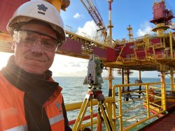
Raoul Quadvlieg, NAM
'A lot of our attention is certainly focused on this subject. It is important in this context that soil subsidence deformation can also have other causes, such as the subsidence deformation of shallow clay and peat layers due to drought, for example. For example, what we want to know, and so does the government as a regulator, is how much soil subsidence is caused by gas extraction and how much by other processes. Knowing this, you can check the subsidence deformation forecast. This is used, among other things, to plan water management measures.'
What role does satellite data play in this?
'Radar satellites measure signals reflected from reflectors on Earth. These can be “free” reflectors, such as paving stones, roofs, train tracks and high-voltage pylons. In addition, we have installed dozens of reflectors ourselves, which are deeply founded. This way you can better separate subsidence on the surface and subsidence deeper in the ground. We then use computer models to check whether the subsidence is as you would naturally expect it to be and whether there are places where it deviates.'

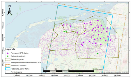
Beeld 1: Ruimtelijke bemonstering van Noord Nederland door de geodetische meettechnieken waterpassing, InSAR en GPS.
How long has NAM been working with radar satellite data?
'We have been working with InSAR: interferometric synthetic aperture radar since 2002, so for more than twenty years. The big advantage of this radar data is that you don't have to go into the field for measurements as much. This means: fewer safety risks for staff and also lower costs.'
What can you see on radar images when they are processed from raw data to a final product?
'You can see the location of the natural reflectors on a map, which serve as measuring points. The amount of ground movement is indicated by means of colours. You can combine this with other map layers, with information relevant to the company above and below ground. By combining processed radar images with, for example, maps of the subsurface and groundwater level changes, you can better interpret the measurements.
Are radar satellites detailed enough for all your applications?
'We use roughly two classes of precision. High resolution radar data (Met TerraSAR-X, Radarsat-XF) are used to monitor deformation at building level. The data from the European Sentinel satellites is slightly less detailed, but often good enough to meet all kinds of legal obligations.'

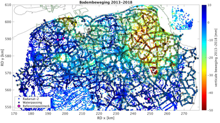
Beeld 2: Bodembeweging (mm) bepaald uit InSAR en waterpassen voor de periode 2013-2018. Deze vergelijkende kaart kan voor de andere tijdvakken niet worden gemaakt, omdat de deformatie bij aansluiting van Envisat (tot 2010) en Radarsat-2 (sinds 2009) op elkaar niet PS-gewijs kan worden berekend.
Do you use satellite navigation in addition to radar satellites?
'Yes, satellite navigation is also used to monitor land subsidence. Dozens of receivers have been installed that measure continuously. These measurements show a very gradual decline. A number of these receivers are integrated with radar reflectors so that the radar data can be compared with the satellite navigation data. NAM also uses receivers for navigation satellites for other measuring work at sea and on land, so that we can precisely locate underground gas pipes and prevent damage from excavation work. More than ten thousand reports of excavation work are processed every year. We are proud that we have not had any damage due to excavation work on our gas pipelines in recent years. A damaged pipe can have serious consequences.'
How can BV Nederland take maximum advantage of all the radar satellite data that comes to us from space every day?
'A step in the right direction is the acceptance of radar data as the primary technology for land subsidence reports. In addition, it helps if companies and institutions work together. We have been doing this since 2002 with the TU Delft radar group. By linking social issues to academic research, you can quickly and specifically develop commercially applicable applications. Many students at TU Delft have graduated or promoted on deformation research with radar images. This has led to successful spin-off companies that offer their services all over the world.'