3-day hackathon leads to concrete and promising satellite applications for the Ministry of Infrastructure and Water Management
Satellite data can help to make public space more efficient and to improve the quality of our soil. This became clear during the Geo-Data Fusion Hackathon, organised by the Ministry of Infrastructure and Water Management (IenW) last week.
Eight teams with a total of more than forty 'hackers' attended the Geo-Data Fusion Hackathon. On June 13, 14 and 17, they each worked on a practical application based on s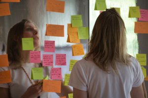
Source: Thijs van der Meijden
atellite data at the LEF Future Center in Utrecht. They worked together with experts from inside and outside the space industry and, amongst other things, used satellite data from the Satellite Data Portal.
IenW organized the hackathon together with the company Social Hackathon, the NL Space Campus, LEF Future Centre, Rijkswaterstaat and the NSO. Three concrete challenges were central: how can you make better use of unused parking spaces? How do you investigate the ecological impact of offshore wind farms? And how can the Netherlands improve the quality of the soil for future generations?
New perspective towards satellite data
On Monday afternoon, June 17, the teams presented their solutions. From a dashboard that visualizes what is happening around wind farms in the sea to active monitoring that keeps track of how many cars drive in and out of an area. And an application that uses machine learning to link soil samples and satellite observations.
Jasper van Loon, board member of the NSO: 'This hackathon attracts many people from outside the space industry. They look with a new perspective at what you can do with satellite data and come up with solutions that we might have never thought of before. We will enter into discussions with IenW and the winning teams to see how they can further develop their idea into an application that can actually be used in practice.'
Parking space becomes public green
The ideas were assessed by a professional jury including representatives of all organizing parties. The jury named the ParkSense team's solution as runner up. The team is invited to further develop its idea into a 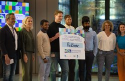
ParkSense, runner-up of the hackathon and winner of the audience award. Source: Thijs van der Meijden
proposal worth ten thousand euros. In addition, ParkSense also received the most votes from the public and thus won the audience prize: VIP access to the ESTEC open day in October.
Jean Swart from the ParkSense team: 'Our idea is to create a vehicle index based on satellite data. Thanks to historical data, you can investigate which parking spaces in public spaces are often empty. And once you know that, you can calculate what happens to traffic flows when you give those parking spaces a different function, such as housing or public greenery.'
The team developed a functioning prototype in a few days. With the grant from the hackathon, she will investigate the limits of the technology used. Swart: 'We wonder how we can work around clouds on satellite images, for example by using data from radar satellites. And we will investigate how we can increase the frequency of new data from once a week to every day.'
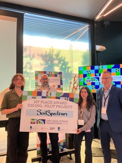
Team SoilSpectrum wins the hackathon
Soil quality dashboard
According to the professional jury, the winner of the hackathon was team SoilSpectrum. The team is invited to submit a proposal worth twenty thousand euros to further develop the idea. Team member Frederik van Oers: 'The European Union is issuing new guidelines to determine whether the soil of member states is in good condition or not. Our application is in line with this. On an accessible dashboard you can see which parts of the Netherlands comply with the directive and which parts of our soil need attention. We have now developed a pilot for a small area. In our assignment proposal we want to add new data sources and thus scale up the application to a larger area.'
Rike van Hattem, senior policy officer at IenW and initiator of the hackathon, is more than satisfied with the results: 'Many smart colleagues work in my ministry, but not everyone is familiar with the possibilities of satellite data. With all the ideas that were devised during this hackathon, I can return to my colleagues and show them how promising the use of satellite data is for the challenges we face as a ministry.'