New European Satellite Sentinel 1 has important implications for the Netherlands
What do a water manager, a bridge builder, and a data scientist have in common? They all rely on radar satellites. And they're not the only ones. Radar data is used in hundreds of applications on Earth, showing whether the ground is subsiding, polar ice is melting, or rainforests are disappearing. We also use it to detect oil leaks or study the aftermath of natural disasters.
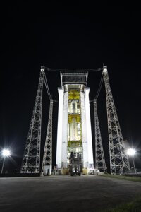
Sentinel 1C ready for launch © ESA
The key to all these discoveries is a continuous stream of radar data from space. For the past decade, this has been provided by two European Sentinel radar satellites. But one of them stopped working at the end of 2021 due to technical issues, and the other has far exceeded its expected lifespan. Universities, governments, and businesses in the Netherlands are therefore eagerly awaiting the launch of a third, brand new radar satellite – Sentinel 1C – on Wednesday, December 4th, aboard a Vega C rocket from French Guiana.
Promoting the Use of Satellite Data
Sentinel 1C is part of the European Copernicus programme, which is widely regarded as the gold standard in Earth observation. Since all data is freely accessible to governments, institutions, citizens, and businesses, the Sentinel satellites are, according to Catharina Bamps from the European Commission's Earth observation unit, "a catalyst for growth, creativity, innovation, and prosperity in Europe."
For this reason, the NSO (Netherlands Space Office) encourages the use of satellite data in the Netherlands. It does so by connecting users and providers of satellite data, fostering innovation – for example, through an SBIR – and sharing valuable knowledge with potential users.
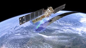
"The only instrument on board Sentinel 1C is a radar, short for radio detection and ranging," explains Anneleen Oyen from the NSO. The satellite sends radio signals to Earth, which are then reflected and captured by a receiver. From this reflection, you can deduce a variety of information. For example, how quickly the ground is subsiding in the province of Groningen, or whether a highway needs maintenance.
A major advantage of radar instruments is that they work in the dark and are not hindered by clouds. "This is particularly useful for floods," says Oyen, "as they are typically accompanied by heavy cloud cover." Radar satellites like Sentinel 1C can help answer questions such as how far floodwaters spread during events like the 2021 Limburg flood, the extent of the damage, and what water managers can do to mitigate the impact.
The shorter the time between two satellite measurements of the same location – the revisit time – the more valuable the data, emphasizes Oyen. "At the moment, we receive a complete radar image of the Earth every twelve days. With the launch of Sentinel 1C, this will be reduced to every six days. This will allow us to monitor the state of our dikes, railways, and other infrastructure with much greater accuracy. And we can better understand the impact of lower or higher groundwater levels on the Netherlands."
© ESA
New: Groundwater Report
Hans van Leeuwen from the Foundation for Applied Water Research (STOWA) knows how important the new Sentinel 1C satellite is for water managers. "Due to climate change, we're experiencing more extreme rainfall. Water managers are faced with a crucial question: how much water should we extract from the ground at what time to better absorb extreme rainfall? We do this, in part, using information from Sentinel 1."
Looking ahead, Van Leeuwen envisions a daily "groundwater report." Such a forecast would be invaluable for water boards to prevent flooding and drought. For farmers, it would help determine the best time to harvest potatoes. And for insurers, urban planners, and governments, it would assist in addressing the effects of land subsidence, which is often caused by low water levels.
Three Major Benefits
Can you also use Sentinel 1C data to assess the quality of bridges, dikes, and roads? Absolutely, says Gert Mulder from Rijkswaterstaat, and with millimetre precision. "You can see how dikes slowly deform, how parts of bridges sink, and how bumps or cracks appear in the asphalt. With satellite data, we can prioritise and plan major infrastructure maintenance for the coming years."
Satellite data offers Rijkswaterstaat three major advantages over manual inspections, Mulder explains. First, satellites can measure large areas in one go, making it far more cost-effective than sending inspectors out. Second, there’s no need to close roads for satellite inspections: "Not only is Rijkswaterstaat happy with that, but so is everyone in the Netherlands." Lastly, thanks to the continuous data stream from all the Sentinel satellites, we can look back up to ten years to track how quickly changes are occurring.
Digital Twin of Earth
Land subsidence in Groningen, sinking dikes in Flevoland, and floods in Limburg are just a few examples of how human actions impact the Earth. To better understand these complex interactions and predict future risks, Femke Vossepoel, Professor of Earth System Simulation at TU Delft, is working on a digital "twin Earth." This computer model is an accurate digital representation of our planet, based on valuable measurement data, including data from the Sentinel 1 radar satellites.
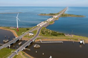
© Ivo Vrancken Rijkswaterstaat
"The great advantage of satellites is that they collect objective data from all over the world," says Vossepoel. One digital twin of Earth helps answer questions from all corners of the globe. For example, how much water can Thailand extract from the ground without making it more vulnerable to floods? How does glacial meltwater affect the flow patterns of the Rhône River? And when will Antarctic ice shelves break off, causing sea levels to rise more rapidly?
Data for Decades
In the Netherlands, it's not just the data from Sentinel 1 satellites that is being used; Dutch companies are also contributing to the satellite itself and the rocket that launches it. Airbus Netherlands built the satellite's solar panels and the intermediate stage of the Vega C rocket that launched it on December 4. APPBV supplied the rocket's igniters.
In 2025, Sentinel 1D is expected to be launched, the fourth radar satellite in the Copernicus programme. This ensures the continuous flow of radar data from space, allowing scientists, policymakers, businesses, and all other users of this satellite data to plan for at least another decade.